InfraIQ – RoadSense
Start Intelligent Road Monitoring
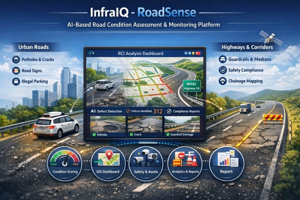
AI-Powered Road Condition Assessment & Digital Road Management

InfraIQ – RoadSense is a next-generation, AI-powered platform for road condition assessment and digital lifecycle management across urban roads and highways, built on Futops’ proprietary DAIOS platform. It seamlessly integrates data capture, AI analytics and GIS intelligence into a single, scalable ecosystem.
By automating everything from video surveys and defect detection to maintenance planning and work order execution, RoadSense empowers governments to transition from reactive repairs to predictive, performance-driven infrastructure management across diverse road networks.
-
Video-Based Survey System
Dashcam-equipped vehicles capture geo-tagged, timestamped footage across the full road network, with day and night capability
-
DAIOS AI Detection Engine
Proprietary computer vision models process every frame to detect and classify 40+ road parameters with contextual severity grading
-
GIS Intelligence Dashboard
Cloud-based platform with colour-coded condition maps, authority-wise road segregation, drill-down to geo-tagged imagery and role-based access
-
Predictive Maintenance Engine
Trend analysis, Road Health Index scoring, and ML-based forecasting enable proactive budget planning and priority maintenance queues
Defining the Standard for Road Intelligence
Everything Road Authority Needs — In One Platform
RoadSense integrates survey operations, AI intelligence, GIS mapping, automated workflows, and predictive analytics into a unified platform — replacing disconnected systems with a single source of truth for road infrastructure management.
GIS Command Dashboard
An interactive, map-centric interface that gives every stakeholder — from field engineers to commissioners — the road intelligence they need, at the right level of detail.
Digital Road Register & Asset Inventory
A structured, searchable database of every road segment and roadside asset — replacing paper registers and spreadsheets with a living digital record.
Alert, Work Order & Escalation System
A complete defect lifecycle management system that ensures no issue goes unresolved — from detection to verified closure, with a full audit trail at every step.
Predictive Maintenance & Analytics
Move from reactive patching to proactive governance. RoadSense's ML engine forecasts road deterioration and prioritises maintenance spend for maximum impact.
Configurable Rules Engine
RoadSense is not a one-size-fits-all tool. Every assessment parameter, SLA timeline, alert rule, and dashboard view is configurable to match your authority's specific operational requirements.
Reporting & Compliance Outputs
Structured report types covering every stakeholder need — from field engineers to commissioners and audit bodies — in government-ready formats.
Holistic Road Parameters Detection — Nothing Goes Unnoticed
The DAIOS AI engine dynamically aligns detection with road classification — ensuring comprehensive evaluation for highways and relevant, standardized assessment for urban roads.
Pavement Condition
- Potholes
- Cracks
- Rutting
- Surface wear
Structural Integrity
- Edge damage
- Shoulder drop
- Settlement
Road Safety
- Road markings
- Delineators
- Reflectors
Traffic Infrastructure
- Signboards
- Street lights
- Signals
Barriers & Protection
- Guardrails
- Crash barriers
- Medians
Drainage & Utilities
- Water stagnation
- Drain covers
- Manholes
Encroachments
- Illegal parking
- Roadside encroachments
- Unauthorized access
Environment & Cleanliness
- Debris
- Vegetation
- Obstructions
Key Features
AI-Based Road Condition Assessment
Automatically detects and classifies pavement defects, structural issues and safety risks for objective, repeatable road evaluation
Context-Aware Multi-Road Intelligence
Adapts detection parameters based on road classification, ensuring relevant, standardized assessment across diverse road networks
Standardized Road Condition Index (RCI)
Computes segment-level condition scores to enable uniform grading, comparison, and data-driven maintenance prioritization decisions
Geo-Tagged Video Survey System
Captures high-resolution, GPS-tagged, time-stamped road data ensuring full traceability, validation and audit-ready inspection records
GIS-Based Command Dashboard
Provides network-wide visualization, segment-level drill-down, and real-time monitoring through an intuitive GIS-enabled control interface
Holistic Parameter Detection Coverage
Detects pavement, assets, safety elements, drainage, and compliance issues ensuring comprehensive and multi-dimensional road assessment
Automated Defect Lifecycle Management
Enables end-to-end workflow from detection to closure with SLA tracking, accountability mapping and operational transparency
Predictive Maintenance & Analytics
Analyzes trends and historical data to predict deterioration, prioritize repairs and optimize long-term maintenance planning
Highway & Corridor Intelligence
Supports chainage-based mapping, corridor monitoring, safety audits and contractor performance evaluation for highway networks
Scalable Cloud-Native Architecture
Designed to handle large-scale road networks with high-performance processing, reliability and seamless scalability
Secure Governance & Access Control
Implements role-based access, encryption, and audit logging to ensure secure, compliant and controlled system usage
Indigenous Proprietary Platform
Fully owned platform with in-house AI, GIS, and analytics ensuring flexibility, control and compliance with government requirements
Benefits
Eliminates Manual Traffic Counting
Replaces manpower-intensive traffic counting with accurate, AI-based automation
Reduces Operational Cost
Minimizes manpower, site visits, logistics, and repeat surveys through accurate first-time data capture
24×7 Continuous Traffic Insights
Captures true traffic behavior beyond short-duration survey windows
Future-Ready Traffic Intelligence
Forms a strong data foundation for ITS, adaptive signals and smart mobility systems
Supports Offline Video-Based Surveys
Analyze MP4 recordings, ideal for temporary surveys and remote locations
Improves Data Accuracy & Consistency
Removes human error and observer bias, delivering reliable traffic insights
Works in Real-World Traffic Conditions
Reliable performance in mixed traffic, congestion and lane-less environments
Scales Easily Across Locations
Designed to scale seamlessly from single junction deployments to corridor-level and full city-wide deployments
Faster Survey Turnaround
Generate traffic counts, classifications and reports in significantly less time
Audit-Ready & Authority-Accepted Outputs
Standardized reports and data formats trusted by consultants and authorities
Data-Driven Infrastructure Planning
Enables informed decisions for road design, capacity planning and targeted infrastructure investments based on actual traffic demand
Supports Historical Trend & Growth Analysis
Enables period-wise and year-on-year traffic comparison for better planning decisions